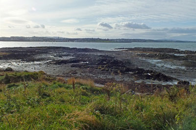
 In the current times, most of us are left with few daily decisions to make. Encouraged as we are to take exercise, one decision might be: do I walk round Ballymacormick Point from Ballyholme to Groomsport and return by the road or vice-versa? Perhaps the clockwise direction of the Irish turas or pilgrimage should apply, although somehow it seems instinctive to me to go this way …
… anyway, we are lucky to have this coastal strip of National Trust property so close to a large town. It was gifted to the Trust by the Kingan family of adjoining Glenganagh in 1953. Had it not been, and had the farmland above been sold, the Point could now be covered in caravans or houses. So let's not take it for granted!
The townland name Baille mic Cormaic, Cormac's settlement, could date from the 13th or 14th centuries, but prior to that there is evidence of an Iron Age to Early Christian era rath or 'forth' on top of the hill: in fact, Islet Hill farmhouse is right in the middle of it! Denis Mayne, looking out his windows in a very dry summer, perhaps that of 1976, gradually began to realise a circle of crop marks was appearing, where the growth was stronger in what had formerly been the outer ditch. This still retained moisture longer.
Many thousands of these small settlements dot Ireland, and part of the bank of one nearby can just be discerned, in the garden of the handsome house on the left of the Groomsport to Bangor road at the top of the hill. Across Ballyholme Bay is what is marked on the 17th century Raven maps as 'The Great Forte Hill' above Kingsland.
The inhabitants of the rath might well have seen Vikings landing in Ballyholme Bay in the 9 th and 10th century! (There is a credible theory that the very name derives from the Old Norse holm a water meadow, this being the land behind the sandhills at the mouth of the river, where the Viking burial was found around 1905.) Our territory then was part of the small kingdom of Blathmac with allegiance to the larger Dal Fiatach dynasty.
Just before the walker reaches the gate on to the Point, there is a long line of boulders starting at high tide mark. It is thought these marked a boundary of kelp-gathering rights, and may be 200 years old. Yet what man-hours and effort must have been needed to transport and align them and where were they sourced?
In the modern era, world events touched Ballymacormick Point! After the Hungarian uprising of 1956, refugees were housed in former wartime huts and looked after warmly by local charities. Children attended local schools before the Hungarians were transported to new lives in Canada. In recent years, one came back to the Town Hall to express his thanks to the people of Bangor. A little-known feature of the Point is the Cold War bunker, one of a chain, into which members of the Royal Observer Corps would descend to observe...well, no-one really knew what …!
So - clockwise or anti-clockwise? Actually, it occurs to me that if dog-walkers go clockwise, it means that Rover can be let off the lead sooner …! As the thatcher from Ahoghill said in broad Ulster-Scots when working on the roof of Cockle Row cottages: "there's more dugs than people round here"!